USGS Youghiogheny River Data
The United States Geological Survey (USGS) has several river monitoring stations along the Youghiogheny river as part of the nation-wide flood alert system. These gages monitor discharge, same as flow-rate, in cubic feet per second (CFS) and gage height, basically the level of the river, in feet. The data can be extracted from the USGS National Water Information System.
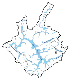
The gage stations of importance to the Deep Creek watershed issues are:
- Hoyes Run => 03076100
- Poland Run => 03075800
- Cherry Creek => 03075905
- Bear Creek => 03076600
- Oakland => 03075500
- Friendsville => 03076500
The river data for the past week for several locations can be found here:
For convenience the data has been extracted from 2010 and forward, although there is a lot more historical information. The data can be accessed from the links in the following table and a graph of the same can be accessed also. The data is as obtained from the website except that the two rows of data that define the column headers have been commented out to facilitation graphing the data with R. In general, discharge and height are available. In recent years water temperature, in degree C, have been added.
- 2015 river data at Friendsville Click here for a graph
- 2014 river data at Friendsville Click here for a graph
- 2013 river data at Friendsville Click here for a graph
- 2012 river data at Friendsville Click here for a graph
- 2011 river data at Friendsville Click here for a graph
- 2010 river data at Friendsville Click here for a graph
- Hoyes: Lat 39°31'32.9", long 79°24'38.7"; DRAINAGE AREA.--250 mi2; PERIOD OF RECORD.--July 2011 to current year; GAGE.--Water-stage recorder and crest-stage gage. Datum of gage is 2,017.47 ft
- Poland Run: Lat 39°29'11.1", long 79°16'35.8"; DRAINAGE AREA.--0.50 mi2; PERIOD OF RECORD.--October 2007 to current year; GAGE.--Water-stage recorder and crest-stage gage. Elevation of gage is 2,480 ft
- Cherry Creek: Lat 39°32'16.8", long 79°18'56.8"; PERIOD OF RECORD.--October 2007 to current year.; DRAINAGE AREA.--13.1 mi2; GAGE.--Water-stage recorder and crest-stage gage. Datum of gage is 2,465.0 ft.
- Bear Creek: Lat 39°39'22.1", long 79°23'38.8"; DRAINAGE AREA.--48.9 mi2; PERIOD OF RECORD.--October 1964 to current year; GAGE.--Water-stage recorder and crest-stage gage. Datum of gage is 1,550.83 ft
- Oakland: Lat 39°25'17.7", long 79°25'25.1"; DRAINAGE AREA.--134 mi2; PERIOD OF RECORD.--August 1941 to current year; GAGE.--Water-stage recorder, crest-stage gage and concrete control. Datum of gage is 2,353.14 ft
- Friendsville: Lat 39°39'13.0", long 79°24'29.9"; DRAINAGE AREA.--295 mi2; August 1898 to December 1904, October 1940 to current year; Water-stage recorder and crest-stage gage. Datum of gage is 1,486.82 ft
Other Important Data
Travel Time Characteristics of Deep Creek Lake Hydropower Releases
This document, in section B, 1989, (other sections of this report can be found under "Resources" below) describes the river flow characteristics, meaning the travel time and shape of the wave that flows down the Youghiogheny when a release is made by the hydroelectric facility.
Resources:
- Most of the reports can be found on the document archives of the Deep Creek Watershed Management Plan work.
- USGS 03075500 YOUGHIOGHENY RIVER NEAR OAKLAND, MD
- USGS 03076600 BEAR CREEK AT FRIENDSVILLE, MD
- USGS 03075905 CHERRY CREEK AT STATE PARK ROAD NEAR MCHENRY, MD
- USGS 03076100 YOUGHIOGHENY RIVER AT HOYES, MD
- USGS 03075800 POLAND RUN NEAR SWANTON, MD
- Youghiogheny River Recreational Capacity Study, 1989
- Section C - Recreational Use assessment, 1989
- Section E - Environmental Impact Assessment, 1989
- Section I - Recreational Capacity Assessment, 1989