Geography
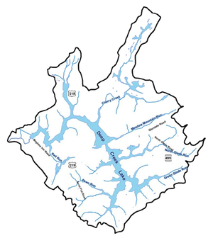
The topographic elevations found within the Deep Creek Lake region are a reflection of the geologic history of the area and the varying erosive rates of different rocks. This physical activity has created elevations which range from more than 3,000 feet above sea level to the full pool elevation of the lake at 2466 feet.
The topography provides the foundation for understanding the other natural features which influence development and land use in the region. The topography determines the watershed boundaries and channels surface water into Deep Creek Lake. The level of the water table generally follows the surface topography and flows down the gradient toward the Lake. In turn, the water table influences to a large degree the types of soils found on-site and their drainage characteristics which may impose constraints on development. Even the vegetation and wildlife observed are affected by the area's topography. Along the stream valley corridors, for example, the high water table, periodic flooding, and other environmental factors combine to produce a unique natural community.
Slope is an expression of how rapidly the elevation changes. Slope is an important factor in determining the suitability of land for various uses. Level terrain is often poorly drained in temperate regions and this can increase development costs owing to surface drainage costs. Gentle slopes (3-8 percent) are prime areas for residential or industrial development. Steep slopes (25 percent or greater) increase development costs by necessitating additional grading. Steep slopes also intensify the erosion and sedimentation problems associated with development.
Garrett County is the westernmost county of the State of Maryland. It was named for John Work Garrett (1820-1884), president of the Baltimore and Ohio Railroad from 1858 until his death in 1884. Its county seat is Oakland.
Garrett County, and much of the western part of Maryland, was originally part of Prince George's County which was incorporated in 1696. Prince George's County was split repeatedly, with Garrett County being split off and formed in 1872.
Garrett County includes eight municipalities, all classified as towns under Maryland law:
- Accident (incorporated 1916)
- Deer Park (incorporated 1884)
- Friendsville (incorporated 1902)
- Grantsville (incorporated 1864)
- Kitzmiller (incorporated 1906)
- Loch Lynn Heights (incorporated 1896)
- Mountain Lake Park (incorporated 1931)
- Oakland (incorporated 1862)
The topography of Garrett County is largely mountains. All of the county lies within the Appalachian Plateau. The average elevation of the county is 2,300 feet above sea level. There are five main mountain ridges: Backbone Mountain, Negro Mountain, Savage Mountain, Meadow Mountain, and Winding Ridge. The highest point in the county is Backbone Mountain, 3,360 feet. The lowest point, 900 feet, is in the middle of Savage River where it empties into the Potomac.
There is a continental divide in Garrett County. It runs along the crest of Backbone and Meadow Mountains; the water flowing down the east slope goes into the Chesapeake Bay via the Potomac River. The water on the west slope flows into the Gulf of Mexico, via the Youghiogheny, Monongahela, Ohio, and Mississippi Rivers. The main tributary of the Potomac is the Savage River on which a large flood control dam was built. The Casselman River is the main tributary of the Youghiogheny.
Resources:
- Most of the reports can be found on the document archives of the Deep Creek Watershed Management Plan work.
- A very impressive website about Garrett County property maps is one from the Department of Planning and Zoning. Do check it out