Before
The history of Garrett County is a record of peaceful settlement and development. No battles were fought here, yet most of the great events and forces of American history played a part in the growth of the county.
The development of several important roads served to open the county to settlers. In some instances the Indian trails were widened. One such trail, Nemacolin's Path, passed through the northern part of this county. General Braddock's army, in 1755, followed this route and cut the first wagon road from Fort Cumberland through the wilderness to the Great Meadows near Uniontown, Pennsylvania. Along this road occurred the opening battle of the French and Indian War when the young Colonel George Washington was defeated at Fort Necessity. This old road remained in use for a number of years.
The Old State Road (the Winchester-Morgantown-Clarksburg Road) built in 1789 through Garrett County was used by settlers going to the new lands opened up by the Louisiana Purchase.
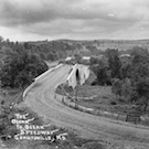
The first great highway linking the eastern and western sections of the United States was the Cumberland Road, which passed through the northern section of Garrett County near the old Braddock Road. This highway, built by the Federal Government between 1811 and 1819, soon became known as the National Road and today is part of U.S. Route 40. The town of Grantsville, named for Daniel Grant of Baltimore, grew along this highway.
The Northwestern Turnpike, another famous east-west route, crossed the southern part of the county. It was proposed by George Washington and surveyed by Crozet, once a soldier in Napoleon's army in Egypt who was then an engineer for Virginia. This famous pioneer route is now part of U.S. Route 50.
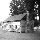
Only a few settlers came into the area before the Revolution. John Friend Sr. and his brothers established the first permanent settlement, "Friends Fortune." at the mouth of the Youghiogheny River, now the town of Friendsville, in 1765. The noted hunter Meshach Browning describes the early days of pioneer life in his book, "Forty-four Years of the Life of a Hunter."
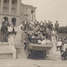
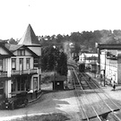
The building of the Baltimore and Ohio railroad through the mountains in the 1850's had an even greater effect on the growth of the county than the coming of the highways. After the construction of the railroad through the southern part of the county, new farm lands were cleared, timber and coal resources were developed, and towns were built along the route. Oakland was laid out in 1849 near the little settlement of McCarty's Mill. Bloomington was laid out in the same year as a coal mining center, and Swanton grew up as a shipping point for lumber.(Postcard History Series)
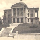
After having been part of Allegany County for 83 years, Garrett County was formed in 1872. Oakland, the commercial center for the southern area, was chosen as the county seat. The county was named for John W. Garrett of Baltimore, who, as president of the Baltimore and Ohio Railroad, had done much to further the development of the area. During his presidency, the railroad built large summer resorts in Deer Park and Oakland. Deer Park became a resort for the wealthy before 1900. President and Mrs. Cleveland spend a week of their honeymoon there in 1866. The town of Mt. Lake Park was organized in 1881 as a summer religious and cultural center. After 1900 Garrett County's popularity as a summer resort declined, but the coming of Deep Creek Lake and the State Parks reversed the trend.
Coal and lumber have always been important industries in the County with the communities of Kitzmiller, Shallmar, Vindex, Kempton, and Jennings developing as mining centers, and Friendsville and Crellin as lumber and coal areas. Grantsville and Accident have remained primarily agricultural centers.
The Garrett County Historical Society was organized in 1941 under the leadership of the late historian Captain Charles E. Hoye, who edited its quarterly publication, the Glades Star. The magazine circulates throughout the United States to more than 500 members and has been continuously published for more than 50 years. The Society maintains its own building on East Center Street in Oakland, the Garrett County Historical Museum.
Indian tribes known to have inhabited Garrett County include the Monongahela - who apparently disappeared around 1600 - the Shawnee, the Delaware and the Iroquois. Records of early explorers and surveyors and archeological evidence suggest that the area was used extensively for hunting and fishing. Evidence also indicates some permanent Indian settlements.
Settlement by European settlers and the subsequent displacement of the Indians began with John Friend in 1765, when his family constructed their homes at the site of a former Indian village. The small community later became known as Friendsville. Indian trails and footpaths in the area became the entryways for Colonial settlers and explorers. Among the more famous of travelers using the pathways was George Washington, who followed them while exploring the area during the French and Indian War.
The history of development follows a pattern similar to other areas of Appalachia. Initial settlement was accomplished by farmers and woodsmen who established self-sufficient communities. These early settlers cleared only enough land to provide for their own crops with a little over for sale or trade. Small grist mills on several tributary streams provided grain milling services to the local farmers.
During the Revolutionary War, Maryland encouraged service in the Continental Army by offering a bounty of 50 acres of land to each of its soldiers who would serve at least three years. Colonel Francis Deakins surveyed approximately 2,774 "military lots" in Garrett County. It is interesting to note that no soldier settled upon his bounty lot, thus allowing most of the land to be sold to speculators for $12 to $15 each. Some Garrett County land still remains divided into military lots.
The development of the Cumberland Road (US 40) as the first National Road spurred the growth of Garrett County. The coming of the railroad in 1852 and the scenic beauty of the area combined to promote the establishment of resort towns. The railroad brought many vacationers; among them were a number of presidents - Grover Cleveland, Ulysses S. Grant, and Benjamin Harrison. Camping, too, became a popular pastime. Henry Ford, Thomas Edison, and Harvey Firestone used Muddy Creek as their campsite.
During this period, Garrett County prospered and grew. Its economy was established on a threefold basis of agriculture, timber and coal extraction, and recreation. This growth precipitated the Governor of Maryland to sign a proclamation declaring Garrett a separate county on December 5, 1872.
Garrett County experienced a decrease in economic prosperity during the early 1900's as the timber, coal and tourism industries declined. However, the construction of Deep Creek Dam and subsequent creation of Deep Creek Lake in 1925 brought a revival in tourism. Acquisition of state forest lands has also contributed to the recreational potential in Garrett County. Current residents of the County are employed in a variety of economic sectors including timber harvesting, mining, agriculture, manufacturing, retail, tourism and government service.
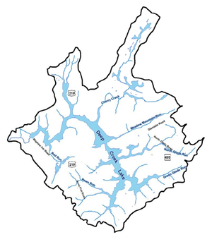
The total area of the county is 656 sq. Miles, of which 8 square miles consist of water and 129 square miles of parks, lakes, and publicly accessible forests. The economy of Garrett County is driven to a large extent by the tourist and vacationers oriented industry because of the parks, the large man-made Deep Creek Lake and the Wisp snow-ski resort.
A more extensive description can be found here.
The USS Navy has named a warship after Garrett County, a tank landing ship.
A great description of Garrett County and its history is by John A. Grant in a "handout" that he prepared for a Garrett County History course at Garrett College during 2001 and 2002. This handout was available on one of Railey Real Estate agent's website, but has now disappeared. I can no longer find it on the Internet. Fortunately, because it was so interesting, I downloaded it from the Internet many years ago. I've reconstructed the document as best as possible and it can be downloaded from here.
Resources:
- Garrett County Historical Society Museums
- Garrett County and The Underground Railroad
- Garrett County Maryland County Information - History from 1908.
- Garrett County, Maryland: History
- The Kendall Lumber Co. of Garrett County, Md
- National Register of Historic Places
- Allegany and Garrett County Families
- The Historical Marker Database
- National Register of Historic Places listings in Garrett County, Maryland
- History/Genealogy at the Ruth Enlow Library of Garrett County
- Maryland Historical Trust - The story of Kitzmiller
- Postcard History Series about Garrett County
- The Western Maryland Coal Fields