Geology
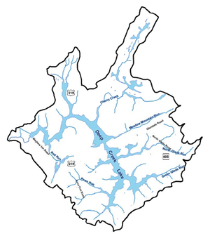
The Deep Creek Lake region is located in a portion of the Allegheny Mountains which is a subdivision of the Appalachian Plateau Physiographic Province (see Geologic Map of Maryland). The Alleghenies are, in geologic terms, old hills. They have a long, complex history that began more than 500 million years ago during the Paleozoic era. For more than 300 million years, the Appalachian area was a long trough filled by an arm of the ocean, and sediments from eroding uplands washed into the area, slowly adding to the accumulating debris of marine skeletons. In later ages, due to the filling process, the trough became a low-lying swamp teeming with primitive insects and reptiles. Two hundred million years ago, conditions changed and a geologic event known as the Appalachian Orogeny (mountain making) occurred. Pressures in the earth's crust caused the area to buckle and contort as the region was uplifted. The sea bottom and swamp sediments, thousands of feet thick, were pressed into high folds. Entombed were plant remains that became today's coal beds.
The northern half of Deep Creek Lake is located on a broad "U" shaped structure, known as a syncline, called the Casselman Basin. Meadow Mountain is the eastern border of this formation. The sediments exposed here are brown colored sandstones and shales of an old formation called the Mauch Chunk. These sediments are from the Mississippian age (approximately 335 million years old). At the State Park, the 200 to 300-foot thick Greenbrier Limestone underlies the Lake and contributes calcium carbonate to buffer the Lake waters from acidic runoffs due to the younger formations of sandstone, shale and coal.
The dam and immediately adjacent areas are in the Upper Youghiogheny coal basin in which sandstones and shales are exposed of the Allegheny/Pottsville formation of Lower Pennsylvanian age (325 million years old). Some lower coal beds may also be exposed.
Southeast of Deep Creek Lake State Park and Meadow Mountain, the southern half of the Lake lies in the "A" shaped Deer Park Anticline composed of the (1) brown colored sandstones and shales of the Pocono Formation of Lower Mississippian age (350 million years old) then (2) further southeast, red to reddish brown sandstones and shales of the Hampshire Formation of Upper Devonian age (365 million years old) and finally (3) the Foreknobs Formation (formerly called the Jennings Formation) consisting of yellowish gray to brown sandstones and shales also of Devonian age. This older formation is located in an area which may be prospective for natural gas exploration from the Oriskany Formation (385 million years old) 5000 to 6000 feet below the surface.
Resources:
- Most of the reports can be found on the document archives of the Deep Creek Watershed Management Plan work.