Summaries of Proposed Projects
Overview
The development of a comprehensive simulation tool for the Deep Creek watershed is a very complex problem. However, the overall problem can be broken down into a number of smaller projects that provide the data for the model. These have to be done, regardless. Here we summarize some of the more readily possible sub-projects or tasks that can be done by various levels of proficiency, from High School Level to PhD programs to subcontracted work. It's all about how much money is available to do them
1. Weather Stations Around the Lake
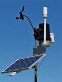
Almost anything we're interested in at looking at the impact on the lake involves knowing something about the weather. There are several weather stations around the lake operated either professionally, such as at the air port, or by amateurs. All have issues that cause them to provide unsuitable, or partially suitable, data. They are either too far from the lake proper, don't measure certain important variables, are not available to the public, are unreliable in operation, or are inappropriately sited.
Weather data are very important. Hence this task is about setting up an appropriate network of weather stations and collect their data in a central repository. This network may include existing weather stations.
Difficulty level: LOW
2. Defining the 2462 and 2466 Lake Contour Lines in Digital Form.
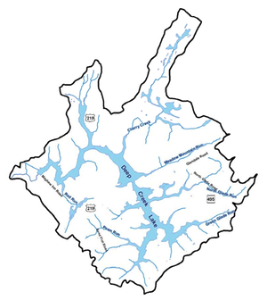
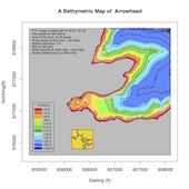 An important aspect of the lake is to understand how deep the waters are at any given location and for any given water level. For this is required a bathymetric map, basically meaning a map of how deep the waters are. Clearly, the depth of the water is defined by what the level of the lake is at a given time. This is under control by Brookfield and the rule bands that is defined for month to month operations.
The accurate contours currently available are for about 3ft or lower than the 2461 water level. This is the limitation imposed by the use of a water vessel to determine water depths when the lake level was at this height.
The existing bathymetry for the lake as a whole and, in more detailed form, for many coves can be found here.. These maps are the best one can make at the time they were made, but with some additional data, these maps can provide more detailed information in the shallower portions of the lake. Such data would be preferred surveyed contour lines around the lake. Fortunately, such data does exist, namely contour lines for 2462 ft and 2466 ft above mean sea level (AMSL) on the buy-down maps, that can be found here. Unfortunately these contours are not available in digital form.
The digital form can be generated in one of two ways: 1) They could be digitized from the hard copy maps, or 2) The digital versions of the buy-down maps are located and processed to retrieve the appropriate data
Difficulty level: LOW
3. Develop a New Youghiogheny River Temperature Model
 During the development of the Deep Creek Watershed Management Plan, it became obvious the the methodology for determining water releases from the lake into the river to keep the stream cool for fish to survive is severely flawed. The method to determine the river water temperature needs to be improved upon to have more reliable forecasts of the potential river water temperature increases. The current model was developed during the time when personal computers were evolving and hence were very simple. With the current maturity of the computer technology, more sophisticated and more accurate models have been made possible. A better model for the river water temperature benefits the fish, the white water rafting community and boating access in coves in the lake.
There is an extensive literature on such models and it should not be a great effort to develop a far better one
Difficulty level: MODERATE TO HIGH
4. A Water Budget Study.
 A water budget is being touted as the solution to allocate the water resource of Deep Creek Lake to its various stakeholders in a more equitable way. This is in lieu of using a specified upper and lower rule bands to define the maximum and minimum lake levels during the year as is currently defined in the permit that is issued by MD Department of the Environment. Today, certain exceptions to go below the lower rule-band are permitted as specified in the operating permit.
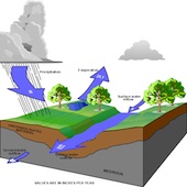
The water budget equation is a simple expression of the fluid dynamics principle of conservation of mass of water flowing in and out of a control volume.
An outline of a possible methodology for developing a water allocation budget for Deep Creek Lake can be found here.
This is an optimization problem, that is, given how much and at what time water comes into the lake, what is the best way to apportion that amount of water to the various needs.
Difficulty level: HIGH
5. Install and Operate an Independent Lake Water Level Measurement Station
 The lake water level is currently operated and maintained by the owners of the hydroelectric generating station, Brookfield, Inc. The data is only accessible by reading the current measurement from their website. To do various types of modeling access to such data for the day, month or year should be readily accessible by the public, but is not today, and must go through an acquisition process with MDE. There is no guarantee that the data can be made available
A separate gage should be installed somewhere in the lake and the data should be available via MDE or DNR or the lake office or a simple website.
Difficulty level: MODERATE
6. Operating Air Quality Monitoring Stations
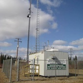 Maryland is going to allow natural gas development in Garrett and Allegheny counties. In order to be able to argue successfully whether fracking causes air pollution we must know what conditions are like when there is no fracking occurring. This is the time to install and operate a number of air quality monitoring stations that could gather for several years existing air quality conditions. Perhaps 3 or 4 air monitoring stations would be adequate to provide the necessary data.
Dr. Mark Castro of Appalachian Laboratory suggests the following equipment for each station.:
- A high quality meteorological station
- Ozone sensor
- Fine particulates (PM2.5) package
- BTEX package
- Methane sensor
The equipment should be placed in a temperature controlled equipment shelter, with power and internet access, calibration standards, and gases to operate each instrument. This equipment is expensive but the data derived from it would be invaluable.
He also recommends that we measures VOCs in the air around each station. This can be accomplished using grab samples and a contract laboratory. Currently, each sample costs close to $200 for 75 VOC compounds (method T0-15).
He notes that the data from his Piney site is available to everyone via EPA's web site and it could be part of the new network of air monitoring stations in Garrett County.
Difficulty level: LOW
7. Identification of Shoreline Erosion Mechanisms
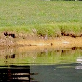
Shoreline erosion at Deep Creek Lake is often a misunderstood subject, mostly because there is no data to quantify it. Often the wake from boats are blamed for eroding shoreline, but it is only a contributing factor, and perhaps only a minor one. Boats on the lake only operate during the daytime and only for three to four months a year. The wind, however, operates year around, 24/7, and is most likely the blame for most of the shoreline erosion. There is anecdotal evidence that over a period of 7 years, one foot of shoreline eroded away every year in a no-wake zone.
The parameters that affect shoreline erosion are mostly wind, fetch, water level, and the nature of the shore itself (steepness and dirt type).
The water level is important because it sets the level at which erosion is most severe. It is not tidal, meaning it does NOT come back to a previous level twice every lunar day (approximately 25 hours), but cycles effectively only once per year.
There has also been an insistence of plantings on the shoreline, but there is lots of evidence that trees that are 10, 20 to 30 years old are falling into the lake. In other words, the root structure is not the issue.
Its desirable to develop an approach to measure the erosion and sedimentation processes at several locations around the lake, considering the steepness of the slope and the soil types.
A more detailed discussion of the subject matter can be found here, and here and a DNR study about sedimentation here.
Difficulty level: HIGH
8. Develop an Annotated Bibliography of All Documents Published by the State and the County Pertaining to the Ecology of the Deep Creek Watershed
Over the years many documents have been published dealing with various aspects of Deep Creek Lake and its watershed. It would be very helpful to have a categorized annotated index of all such reports and a library from which the can be retrieved. One option may be to restructure the deepcreekwatershed.org website to include these reports. Many of the reports already exist on that website.
Difficulty level of this activity: LOW
9. Development of a Notification List Server
 "Communications" is constantly being cited as the most important issue when dealing with keeping people informed. It' not sufficient to put an ad in the paper or to put a notification on the website or to make a radio announcement. Having a centralized function that allows one to inform people is a very noteworthy subject. Further discussion of this topic can be found here. This website believes that there is a better solution and one that should be tried.
Difficulty level: MODERATE
10. Develop a Database for the Water Quality Information Collected by the Health Department
 The Health Department collects water quality data from the lake. The records are kept in written form. Such data can be important in comparing water quality improvements that are made with various measures. Such data should be available in digital form.This task is to accomplish this.
Difficulty level: LOW
Resources:
- Many reports that can support these efforts can be found on the document archives of the Deep Creek Watershed Management Plan work.