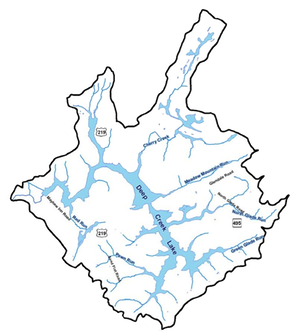
Maps
Links to Satellite Maps of Deep Creek Lake
Satellite maps give wonderful overviews of areas from the sky. There are a variety of services that supply maps (photos)in different formats and different resolutions. This page provide links to some of the better ones of the Deep Creek Lake area.
- This is a NOAA product (1:4514.5)(1-inch = 222 ft). It was found previously as on this site, , with this search file -map/ncs/?thm=themeHourly&layers=1- but the link broke.