Buy-down Maps
A buy-down map shows the property that you, as a lakeside property owner, have bought, or had the opportunity to buy, when the Buy Down program was in existence. The Buy Down program lasted for about 8 years, and was terminated in June of 2008. The buy-down maps show the attributes of the buy-down areas.
So, what was this Buy Down Program? The State Maryland bought the lake bottom below elevation 2466 in February of 2000 for $7.8 million from Penelec (Pennsylvania Electric Company). It contained 4,406 acres. The State also bought Penelec’s residue containing 584 acres for $9.8 million, both according to the land records. It should be noted that the Maryland DNR had been managing Deep Creek for many years prior to 2000. Subsequent to the purchases of the land parcels, the State established and surveyed a 25 ft wide buffer strip around the lake. As a result there was excess property between that perimeter and the Penelec monuments. To recoup some of this $9.8 million, the State offered adjacent landowners the opportunity to ”buy-down” or purchase some of this excess property from the State.
A lakefront property own could purchase that excess property adjacent to their property at $0.39 per square foot. Unfortunately, it came with a conservation easement, meaning that you were prohibited from cutting any vegetation (trees) or building any permanent structures on it. Basically, you were allowed to use the area and pay annual property taxes on it.
The sale of the buydown parcels did not generate anywhere near $13 million. Because DNR wanted to keep a 25 foot buffer and tributary exclusion, not all of the 584 acres were offered for sale, and not all of the parcels that were offered sold.
Purchasing this excess property did come with some benefits, but these benefits affected only a small number of owners. - 1. You got what were called “relaxed” standards when applying for a zoning variance and 2. If you were on a septic system and it fails, you can apply to the state to get permission to extend your drain field in to this excess land area.
A sample of the conservation easement is provided here (4.1 MB). If you have questions about this, call the DNR Lake management at (301) 387-4111
We have assembled all of the buy-down maps that define the legal descriptions for these excess parcels.
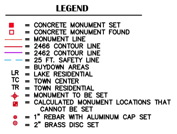
The legend for the symbols used on these maps is shown in the graphic below.
Click here to find the buy down map relevant to your property.


