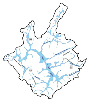
Maps
This is a collection of maps provided to me and collected from various websites that pertain to Deep Creek Lake. Sometimes the reference is not apparent and often unknown. Sometimes the maps are dated and new ones are probably available by contacting the office that they came from.
Bathymetry
- The bathymetry (water depth) of Deep Creek Lake. [0.4 MB]
- An older bathymetry map of Deep Creek Lake (date unknown) [10.7 MB].
- Old Fisherman's Map. [0.3 MB]
- Two maps of unknown origin [2.6 and 2.9 MB]
- Bathymetry of many coves from the 2011 DNR data set
Geology
- The geology of Deep Creek Lake area. [0.3 MB]
- Garrett County Geology. [15.3 MB]
- GC Geology Maps with Additional Contours.[28.3 MB]
Land Features
- The sub-watersheds of Deep Creek Lake. [1.3 MB]
- Mineral rights sold. [1.2 MB]
- Satellite Maps of Deep Creek Lake. [? MB]
Topography
- The land prior to the formation of Deep Creek Lake. [5.2 MB]
- USGS Quadrangle Maps Surveyed around 1898. A series of six maps.
Government Definitions
- Water Appropriation Permits of the Deep Creek Lake Watershed. [1 MB]
- Garrett County Subdivision Ordinance Map, 2010. [2.5 MB]
- The Deep Creek Lake Watershed Zoning Map, 2010. [1.4 MB]
- Map of the High Quality Waters of Garrett County - March 2010. [2.0 MB]
- Properties in Garrett County with mineral rights sold to third parties - around 2014? [0.7 MB]
- A series of maps describing the distribution of various environmental parameters around Garrett County